Parade of storms across southwest Arkansas

(Damage assessments and cleanup/service restorations continue after the wild weekend of severe weather. Here is an overview of some of the activities.)
Three rounds of severe thunderstorms battered southwest Arkansas Saturday night and Sunday morning. All or parts of the region were under tornado warnings and severe thunderstorm warnings as the storms entered Arkansas from southeast Oklahoma and northeast Texas.


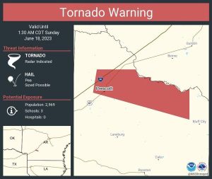
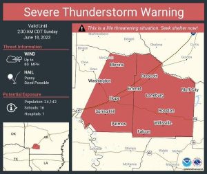
After the initial round of storms Saturday night, the early Father’s Day morning storms prompted the National Weather Service in Shreveport to issue numerous warnings. Two examples are the Tornado Warning that expired at 1:30 am in Nevada County and the Severe Thunderstorm Warning that expired at 2:30 Sunday morning for Hempstead and Nevada Counties. National Weather Service-Shreveport radar indicated a possible tornado along with pea-sized hail. The Weather Service described the Severe Thunderstorm Warning as “…a life-threatening situation. Seek shelter now!” 70 mile per hour wind and nickel-size hail were reported in this instance.
After daybreak Sunday the last round of storms saw more severe thunderstorm warnings issued.
Numerous power outages currently affect the region. But much of the damage occurred late last week in previous storms that battered the region, particularly the baseball and above size hail.
SWEPCO crews continue responding to Friday’s severe storms that caused major damage to SWEPCO’s transmission system, the backbone of SWEPCO’s energy delivery network. The additional severe storms overnight Saturday and Sunday added an additional 21,000 customers to those without power.
“SWEPCO crews, together with more than 2,800 utility professionals from AEP Texas, Appalachian Power, Indiana & Michigan Power, and Kentucky Power as well as other support from Missouri and Oklahoma are continuing to rebuild our power delivery system and restore everyone’s service,” the company said.
At peak, close to a quarter of a million SWEPCO customers lost power after the hurricane-force winds caused significant damage to the power delivery system across SWEPCO’s service area. As of 9:30 am Sunday, approximately 58,997 customers have had power restored; an estimated 191,003 SWEPCO customers remain without power. Friday’s storms included a National Weather Service confirmed EF-1 half-mile wide tornado that touched down in Panola County, Texas and crossed into Caddo Parish, Louisiana.
Work continues, weather permitting, to rebuild SWEPCO’s energy delivery system with continued focus on repairs to SWEPCO’s transmission system.
Approximately 60 Transmission and Distribution stations were impacted, and 50 transmission lines were forced out of service due to tree and structure damage caused by the extreme weather. SWEPCO’s utility poles and distribution wires serving individual homes and businesses also experienced extensive damage.
Damage to transmission lines can result in significant outages.
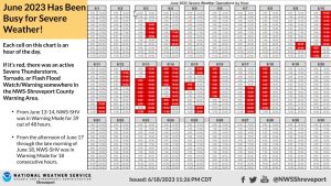
The National Weather Service in Shreveport issued this statement: “If you think the last week has been very busy in terms of severe weather in the Four State Region, you’re right. We did a quick off-the-cuff estimate. This chart shows every hour of the day, so far in the month of June. Red colored hours show that our office was in Warning Operations. In other words, there was an active Severe Thunderstorm, Tornado, or Flash Flood Watch/Warning somewhere in our County Warning Area. The two big takeaways: from 6/13-6/14 we were dealing with severe weather for 39 out of 48 hours. From the afternoon of 6/17 through the late morning of 6/18, we were in Warning Operations for 18 consecutive hours.”


