

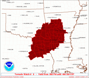
Tornado Watch in effect until 4:00 am Friday

URGENT – IMMEDIATE BROADCAST REQUESTED
Tornado Watch Number 9
NWS Storm Prediction Center Norman OK
955 PM CST Thu Jan 11, 2024
The NWS Storm Prediction Center has issued a
* Tornado Watch for portions of parts of western and central Arkansas
northwestern Louisiana
southeastern Oklahoma
northeast Texas
* Effective this Thursday night and Friday morning from 955 PM until 400 AM CST.
* Primary threats include…
A few tornadoes and a couple intense tornadoes possible. Scattered large hail and isolated very large hail events to 2
inches in diameter possible. Scattered damaging wind gusts to 70 mph possible.
SUMMARY…Strong/locally severe thunderstorms have developed this evening across the Arkansas vicinity, with additional storm development expected over the next couple of hours along the cold front, across northeastern Texas and spreading across the Arklatex region overnight. The strongest storms across this region will be capable of producing damaging wind gusts and large hail, with a couple of tornadoes also possible.
The tornado watch area is approximately along and 80 statute miles north and south of a line from 55 miles north of Corsicana TX to 45 miles east of Hot Springs AR.
PRECAUTIONARY/PREPAREDNESS ACTIONS…
REMEMBER...A Tornado Watch means conditions are favorable for tornadoes and severe thunderstorms in and close to the watch
area. Persons in these areas should be on the lookout for threatening weather conditions and listen for later statements and possible warnings.