
URGENT – WINTER WEATHER MESSAGE
National Weather Service Shreveport LA
137 PM CST Wed Jan 21 2026
Sevier-Howard-Little River-Hempstead-Nevada-Miller-Lafayette-
Columbia-Union-Caddo-Bossier-Webster-Claiborne-Lincoln-Union-De
Soto-Red River-Bienville-Jackson-Ouachita-Sabine-Natchitoches-
Winn-Grant-Caldwell-La Salle-McCurtain-Red River-Bowie-Franklin-
Titus-Camp-Morris-Cass-Wood-Upshur-Marion-Smith-Gregg-Harrison-
Cherokee-Rusk-Panola-Nacogdoches-Shelby-Angelina-San Augustine-
Sabine-
Including the cities of Jena, Nacogdoches, Mount Pleasant,
Shreveport, Marshall, Grayson, Big Sandy, Many, Carthage, Olla,
Coushatta, Haynesville, Stamps, Zwolle, Natchitoches, Mansfield,
Martin, Lone Star, Queen City, Rusk, Ruston, Hawkins, Hughes
Springs, Bernice, Mount Vernon, Colfax, Lewisville, Montgomery,
Tyler, Pineland, Winnsboro, Arcadia, Springhill, Naples,
Prescott, Longview, Monroe, Bossier City, Dierks, Pleasant Hill,
Jefferson, Idabel, Homer, El Dorado, Gilmer, Clarks, Mineola,
Columbia, Clarksville, Omaha, Jacksonville, Farmerville, San
Augustine, Pittsburg, De Queen, Center, Bradley, Magnolia,
Lufkin, Minden, Winnfield, Quitman, Stonewall, Nashville, Midway,
Henderson, Bogata, Daingerfield, Texarkana, Hemphill, Jonesboro,
Logansport, Mineral Springs, Gibsland, Atlanta, Linden, Ashdown,
Dry Prong, Hope, Ringgold, and Broken Bow
137 PM CST Wed Jan 21 2026
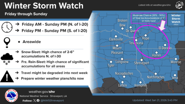
…WINTER STORM WATCH REMAINS IN EFFECT FROM FRIDAY MORNING THROUGH SUNDAY MORNING…
* WHAT…Heavy mixed precipitation possible. Storm total snow and
sleet accumulations of 1 to 3 inches are anticipated with areas of
up to 5 inches possible, particularly near and north of I-30. Ice
accumulations between one quarter and three quarters of an inch
are expected, with localized accumulations of up to or exceeding 1
inch possible.
* WHERE…Portions of south central and southwest Arkansas, north
central and northwest Louisiana, southeast Oklahoma, and east and
northeast Texas.
* WHEN…From Friday morning through Sunday morning.
* IMPACTS…Expect power outages and tree damage due to the ice.
Travel could be impossible. The hazardous conditions could impact
the Friday morning and evening commutes.
PRECAUTIONARY/PREPAREDNESS ACTIONS…
Monitor the latest forecasts for updates on this situation.
Persons should consider delaying all travel. If travel is absolutely
necessary, drive with extreme caution. Consider taking a winter
storm kit along with you, including such items as tire chains,
booster cables, flashlight, shovel, blankets and extra clothing.
Also take water, a first aid kit, and anything else that would help
you survive in case you become stranded.