

URGENT - FIRE WEATHER MESSAGE
National Weather Service Shreveport LA
1225 PM CDT Thu Oct 15 2026

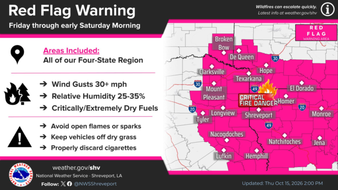
...RED FLAG WARNING IN EFFECT FROM 10 AM FRIDAY TO 1 AM CDT SATURDAY
DUE TO GUSTY WINDS, LOW RELATIVE HUMIDITY, AND CRITICALLY DRY FUELS
FOR PORTIONS OF SOUTH CENTRAL AND SOUTHWEST ARKANSAS, NORTH CENTRAL
AND NORTHWEST LOUISIANA, SOUTHEAST OKLAHOMA, AND EAST AND NORTHEAST
TEXAS...

Sevier-Howard-Little River-Hempstead-Nevada-Miller-Lafayette-
Columbia-Union-Caddo-Bossier-Webster-Claiborne-Lincoln-Union-De Soto-
Red River-Bienville-Jackson-Ouachita-Sabine-Natchitoches-Winn-Grant-
Caldwell-La Salle-McCurtain-Red River-Bowie-Franklin-Titus-Camp-
Morris-Cass-Wood-Upshur-Marion-Smith-Gregg-Harrison-Cherokee-Rusk-
Panola-Nacogdoches-Shelby-Angelina-San Augustine-Sabine-
1225 PM CDT Thu Oct 15 2026

...RED FLAG WARNING IN EFFECT FROM 10 AM FRIDAY TO 1 AM CDT
SATURDAY...

The National Weather Service in Shreveport LA has issued a Red Flag
Warning in effect from 10 AM Friday to 1 AM CDT Saturday.

* AFFECTED AREA...Portions of south central and southwest Arkansas,
  north central and northwest Louisiana, southeast Oklahoma, and east
  and northeast Texas.

* TIMING...From 10 AM Friday to 1 AM CDT Saturday.

* WINDS...North winds 10 to 25 mph with gusts up to 35 mph.

* RELATIVE HUMIDITY...Minimum Relative Humidity between 25 to 35
  percent.

* IMPACTS...Any fires that develop will spread rapidly. Outdoor
  burning is not recommended.

PRECAUTIONARY/PREPAREDNESS ACTIONS...

Follow all fire restrictions. One less spark, one less wildfire.

A Red Flag Warning is issued when we identify weather conditions that
promote rapid spread of fire which may become life-threatening. This
does not mean there is a fire. These conditions are either occurring
now or will begin soon. It is important to have multiple ways to
receive information from authorities.
---
URGENT – WEATHER MESSAGE
National Weather Service Shreveport LA
1216 PM CDT Thu Oct 15 2026
Sevier-Howard-Little River-Hempstead-Nevada-Miller-Lafayette-
Columbia-Union-Caddo-Bossier-Webster-Claiborne-Lincoln-Union-De Soto-
Red River-Bienville-Jackson-Ouachita-Sabine-Natchitoches-Winn-Grant-
Caldwell-La Salle-McCurtain-Red River-Bowie-Franklin-Titus-Camp-
Morris-Cass-Wood-Upshur-Marion-Smith-Gregg-Harrison-Cherokee-Rusk-
Panola-Nacogdoches-Shelby-Angelina-San Augustine-Sabine-
Including the cities of Carthage, Natchitoches, Haynesville,
Mansfield, Dierks, Homer, Gibsland, Springhill, De Queen, San
Augustine, Zwolle, Farmerville, Grayson, Bernice, Prescott, Hawkins,
Jefferson, Henderson, Mount Vernon, Jacksonville, Lone Star, Omaha,
Minden, Bogata, Lewisville, Bossier City, Jena, Arcadia, Stonewall,
Naples, Columbia, Quitman, Magnolia, Center, Jonesboro, Idabel,
Monroe, Gilmer, Big Sandy, Shreveport, Winnfield, Mount Pleasant,
Many, Queen City, Linden, Clarks, Hope, Logansport, Winnsboro,
Texarkana, Mineral Springs, Ashdown, Hemphill, El Dorado, Midway,
Coushatta, Atlanta, Marshall, Dry Prong, Pineland, Longview,
Daingerfield, Pleasant Hill, Ruston, Mineola, Stamps, Olla,
Nacogdoches, Pittsburg, Montgomery, Ringgold, Hughes Springs,
Nashville, Lufkin, Colfax, Clarksville, Rusk, Tyler, Bradley, Broken
Bow, and Martin
1216 PM CDT Thu Oct 15 2026
…WIND ADVISORY IN EFFECT FROM 4 AM FRIDAY TO 1 AM CDT SATURDAY…
* WHAT…North winds 10 to 25 mph with gusts up to 35 mph expected.
* WHERE…Portions of south central and southwest Arkansas, north
central and northwest Louisiana, southeast Oklahoma, and east and
northeast Texas.
* WHEN…From 4 AM Friday to 1 AM CDT Saturday.
* IMPACTS…Gusty winds will blow around unsecured objects. Tree
limbs could be blown down and a few power outages may result.
PRECAUTIONARY/PREPAREDNESS ACTIONS…
Winds this strong can make driving difficult, especially for high
profile vehicles. Use extra caution.
Secure outdoor objects.